View Arctic Cruise 2012 in a larger map
This blog entry is about the flight between Iqaluit and Resolute Bay. Bear in mind that we'd already flown about three or four hours from Ottawa to Iqaluit, then some of us switched to a smaller turboprop aircraft for the rest of the trip - another three or so hours! The reason for splitting the group between two aircraft after Iqaluit is that the airstrip at Resolute is just gravel so can't accommodate a fully-loaded jet!
Nunavut, by the way, is Canada's newest territory - formed in 1999 when there was a juggling of the borders between our northern-most territories to make a more equitable governing region for the people who live there.
The charter airline we traveled on was First Air - LOVE them - if just for the reason that they serve MILK with tea and don't expect us tea-totallers to drink half-n-half or (ick!) cream in our favourite hot beverage!
All of these photos were taken through smeary, scratched, grubby aircraft portholes (that's my excuse and I'm sticking to it)!
 |
| Iqaluit Airport |
Rolling below us was the most amazing variety of colours and textures:
 |
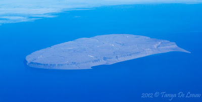
| Prince Leopold Island (more on this later) |
 |
| I've Never Seen an Aircraft Shadow Like This One! |
 |
| Yes, a Very Large Aircraft Parked in the Middle of the Tundra |
 |
| Our First Glimpse of the 100m Clipper Adventurer |
 |
| The Community of Resolute - see our Water Taxis on the Beach? |


Really excellent aerial photos, but I don't accept the implicit suggestion of a supernatural passenger aboard the aircraft.
ReplyDelete